June 19, 2026
Massive Continent-Sized Structure Discovered 3km Beneath Antarctica – Newsy Today
Scientists have discovered a massive, fan-shaped network of deep basins hidden nearly 3 kilometers beneath the Antarctic ice sheet. According to a study published in Nature Geoscience, this geological structure—spanning a 2,000-kilometer coastline—acts as a primary drainage system that dictates how ice moves toward the ocean. Led by geophysicist Egidio Armadillo of the University of […]
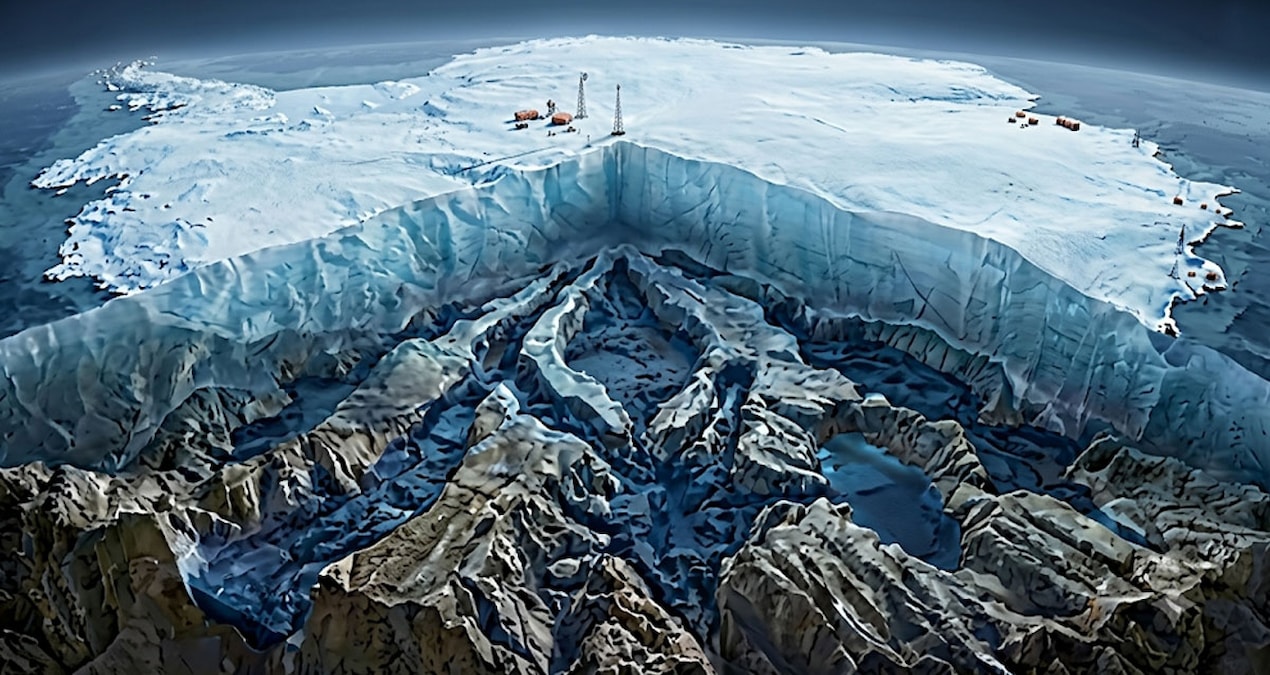
Scientists have discovered a massive, fan-shaped network of deep basins hidden nearly 3 kilometers beneath the Antarctic ice sheet. According to a study published in Nature Geoscience, this geological structure—spanning a 2,000-kilometer coastline—acts as a primary drainage system that dictates how ice moves toward the ocean. Led by geophysicist Egidio Armadillo of the University of Genoa, the research team identified this “megastructure” by synthesizing decades of seismic data, radar scans, and subglacial topographical maps.
How was the hidden Antarctic basin network discovered?
Researchers uncovered the Eastern Antarctic Fan-Shaped Basin Province (EAFBP) by using advanced computer modeling to simulate the continent’s landscape without its 27 million cubic kilometers of ice. By applying these models to seismic readings and radar surveys, the team identified a central focal point near the South Pole. From this pivot, a series of deep troughs radiate outward, similar to the ribs of an opening hand fan. Previously, individual features like the Wilkes and Aurora basins were studied in isolation; this new data proves they are interconnected components of a single, continental-scale system.
Did you know?
The bedrock beneath Antarctica is not a flat surface. When the massive weight of the ice sheet is removed, the Earth’s crust “rebounds,” revealing complex valleys and mountain ranges that physically channel the flow of glaciers.
Why does this basin network matter for climate change?
The EAFBP is critical for predicting future sea-level rise because ice does not melt in a uniform direction. According to the study, ice flow is largely determined by the topography of the underlying bedrock. Glaciers act like rivers; they follow the path of least resistance through these newly mapped troughs. By understanding the orientation of these basins, glaciologists can more accurately forecast which sections of the East Antarctic ice sheet are most vulnerable to rapid thinning as ocean temperatures rise.
How does this discovery compare to previous Antarctic models?
Historically, scientific models relied on fragmented data from isolated regions like the Vostok Lake area. The EAFBP study represents a shift toward a holistic, continent-wide view of subglacial geology. While earlier maps focused on localized flow, the Nature Geoscience findings demonstrate a “rotational extension” process—where the Earth’s crust stretched and rotated around a central point. This provides a clearer, more systemic map of the continent’s foundation than was possible just a decade ago.
• What is the EAFBP? It is a newly identified, 2,000-kilometer-wide network of interconnected basins beneath the East Antarctic ice sheet.
• Why is it shaped like a fan? Researchers believe the structure formed through “rotational extension,” where the crust stretched and rotated around a central point near the South Pole.
• Does this change sea-level predictions? Yes. By mapping these troughs, scientists can better predict the direction and speed of ice loss, improving the accuracy of global sea-level rise models.
• How deep are these basins? The network sits approximately 3.2 kilometers (about 2 miles) beneath the current ice surface.
Stay informed on the latest developments in climate science. Sign up for our weekly newsletter to receive updates on polar research and environmental breakthroughs directly in your inbox.…Read more by Chief Editor