July 21, 2026
Tropical Storm Bertha brings flash flood and storm surge threat from Florida to Louisiana
Tropical Storm Bertha, the second named storm of the 2026 Atlantic hurricane season, formed over the northeastern Gulf at 19:00 CDT on July 20, 2026 (00:00 UTC on July 21) and strengthened to 85 km/h (50 mph) by 06:00 UTC. A Tropical Storm Warning and Storm Surge Watch are in effect along sections of the […]
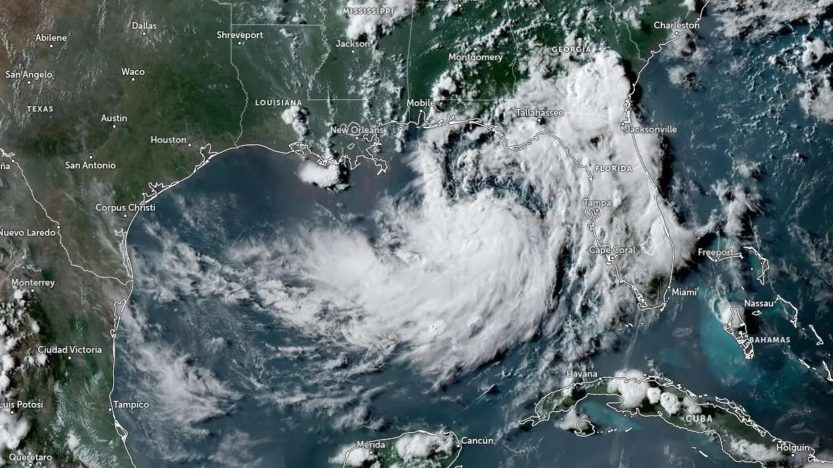
Tropical Storm Bertha, the second named storm of the 2026 Atlantic hurricane season, formed over the northeastern Gulf at 19:00 CDT on July 20, 2026 (00:00 UTC on July 21) and strengthened to 85 km/h (50 mph) by 06:00 UTC. A Tropical Storm Warning and Storm Surge Watch are in effect along sections of the northern Gulf Coast, where heavy rainfall, flash flooding, coastal inundation, dangerous surf, and rip currents were forecast from western Florida into southern Louisiana.
Tropical Depression Two (soon to become Tropical Storm Bertha) satellite image at 22:50 UTC on July 20, 2026. Credit: NOAA/GOES-East, Zoom Earth, The Watchers
At 01:00 CDT (06:00 UTC) on July 21, Bertha’s center was located about 205 km (125 miles) south of Panama City, Florida, and 320 km (200 miles) southeast of Mobile, Alabama. The National Hurricane Center (NHC) reported that the storm was moving northwest at 4 km/h (2 mph), with a minimum central pressure of 998 hPa. Tropical-storm-force winds extended as far as 110 km (70 miles) from the center.
A Tropical Storm Warning is in effect from the Alabama–Florida border westward to the Jefferson/Plaquemines Parish border in Louisiana. Tropical-storm conditions are expected somewhere within the warning area within 36 hours.
A Tropical Storm Watch is in effect from the Bay/Gulf County line in Florida westward to the Florida–Alabama border and from west of the Jefferson/Plaquemines Parish border to Morgan City, Louisiana. The watch includes metropolitan New Orleans, Lake Pontchartrain, and Lake Maurepas. Tropical storm conditions are possible in the Florida Panhandle later on July 21 and in watched portions of Louisiana from late July 21 into July 22.
A Storm Surge Watch extends from the Alabama–Florida border to the mouth of the Mississippi River, indicating the possibility of life-threatening inundation from rising coastal water within 48 hours. The NHC said additional watches or warnings could be required later on July 21.
Peak water levels of 0.6–1.2 m (2–4 feet) above normally dry ground are forecast from the mouth of the Mississippi River to the Alabama–Florida border if the surge coincided with high tide. Levels of 0.3–0.9 m (1–3 feet) were forecast from Morgan City to the mouth of the Mississippi River, in Lake Pontchartrain, and along the Florida coast from Indian Pass to Chassahowitzka.
The deepest water was expected along the immediate coast, with inundation dependent on Bertha’s track, local coastal features, and the timing of the surge relative to the tidal cycle.
Bertha is forecast to produce 50–100 mm (2–4 inches) of rainfall through Thursday, July 23, along the Gulf Coast and adjacent inland locations from western Florida into southern Louisiana, including southern Alabama and Mississippi, with isolated totals near 200 mm (8 inches) possible. This could produce flash flooding, especially in urban areas.
Swells generated by Bertha are affecting sections of Florida’s Gulf Coast and are forecast to spread westward during the week. Weather officials warned that the swells would produce life-threatening surf and rip-current conditions.
The NHC forecast a slow northwestward to west-northwestward movement on July 21, followed by a turn toward the west during the middle of the week. Bertha was expected to move near or along the northern Gulf Coast during the following several days.
Bertha is expected to move slowly northwest to west-northwest on July 21 before turning westward during the middle of the week. On the forecast track, the storm is expected to move near or along the northern Gulf Coast during the following several days.…Read more by Teo Blašković